


When one speaks of ruby, the Mogok Stone Tract in Upper Burma immediately springs to mind. Lying approximately 644 km (400 miles) north of Rangoon, Mogok has for the past 800 years been the premier source of fine rubies. It is an area steeped in legend and its story embraces not only gems, but also the early exploration and expansion of the European colonial empires into Asia.
The town of Mogok (1500 m) is located in the Katha district of Upper Burma. Consisting of heavily-jungled hills rising to a height of 2347 m (7700 ft) above sea level, the ruby mines district covers about 400 sq miles, although only a portion (70 sq miles) is gem bearing. Considered one of the most scenic areas in Burma, it is home to a number of colorful ethnic groups, as well as a variety of wildlife, including elephants, tiger, bear and leopard.
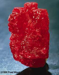
Figure 3. Pigeon's Blood
 Left: The 196-ct Hixon Ruby of the Los Angeles County Museum of Natural History is one of the finest Burmese ruby crystals on public display. Unfortunately, such crystals are all too rare – most are immediately cut, since the market for cut stones is far larger than that for mineral specimens. Left: The 196-ct Hixon Ruby of the Los Angeles County Museum of Natural History is one of the finest Burmese ruby crystals on public display. Unfortunately, such crystals are all too rare – most are immediately cut, since the market for cut stones is far larger than that for mineral specimens.
Right: These extraordinary rubies, at 5.56 and 5.25 ct., represent a lifetime's toil. They are mounted in the traditional Burmese manner, with the gold setting improving the stones' color, as well as acting as a mirror to increase the gems' brilliance.
Mogok Rubies The Ruby is a gemstone of the multi-colored corundum family – the second hardest natural mineral known to man. Our gemstones come from Mogok, Myanmar. They are the most sought after precious stones in the world because of their color often referred to asPigeon Blood Ruby red. The Ruby is a gemstone of the multi-colored corundum family – the second hardest natural mineral known to man. Our gemstones come from Mogok, Myanmar. They are the most sought after precious stones in the world because of their color often referred to asPigeon Blood Ruby red.Read more on Mogok Rubies
myanmar-ruby.
| ||||||||

Burmese jade is always jadeite and that's the better material for exquisite carving and other jewelry. There are two variants this are jadeite and nephrite, Chinese jade is mostly nephrite unless its smuggled or officially imported from Myanmar and just called Chinese once it's in the country but finally nobody cares anyway where the mineral is coming from, the people want beautiful jewelry plus maybe a Buddha statue and other green items.
The material is mined in the north before the high mountains which are extending from the Tibetan Himalayas, the mining areas are around Mogaung and other dykes in Kachin state. Boulders of good quality are sometimes up to around fifty meters below ground and several hundred tons heavy, it's plentiful but the real good one is difficult to find since how to look into the stone?
Jadeite is the real good stuff, nephrite is the other, nephrite is rather dull and of low level. All jadeite sold today is actually from Myanmar, Chinese jade is nephrite produced since several thousand years. The stones comes in different colors just like a rainbow, there is lavender, green jade, white, purple, pink and all shades in between.
The valuable parameter with is the transparency or translucency the more of this the higher the price. Since Myanmar is the number one in the green stone business no wonder that there are plenty of jade shops and a so called emporiums where the minerals is on auction twice per year. The permanent shopping areas are at the Yangon Bogyoke Market and the Gem Museum in Yangon.
Inside Story - Myanmar's future challenges
Imperial Burma
Pagan gradually grew to absorb its surrounding states until the 1050s–1060s when Anawrahta founded the Pagan Empire, the first ever unification of the Irrawaddy valley and its periphery. In the 12th and 13th centuries, the Pagan Empire and the Khmer Empire were two main powers in mainland Southeast Asia.[31] The Burmese language and culture gradually became dominant in the upper Irrawaddy valley, eclipsing the Pyu, Mon and Pali norms by the late 12th century. Theravada Buddhism slowly began to spread to the village level although Tantric, Mahayana, Brahmanic, and animist practices remained heavily entrenched. Pagan's rulers and wealthy built over 10,000 Buddhist temples in the Pagan capital zone alone. Repeated Mongol invasions (1277–1301) toppled the four-century-old kingdom in 1287.[32]
Temples at Mrauk U

Pagan's collapse was followed by 250 years of political fragmentation that lasted well into the 16th century. Like the Burmans four centuries earlier, Shan migrants who arrived with the Mongol invasions stayed behind. Several competing Shan states came to dominate the entire northwestern to eastern arc surrounding the Irrawaddy valley. The valley too was beset with petty states until the late 14th century when two sizable powers, Ava Kingdom and Hanthawaddy Kingdom, emerged. In the west, a politically fragmented Arakan was under competing influences of its stronger neighbors until the Kingdom of Mrauk U unified the Arakan coastline for the first time in 1437.
Early on, Ava fought wars of unification (1385–1424) but could never quite reassemble the lost empire. Having held off Ava, Hanthawaddy entered its golden age, and Arakan went on to become a power in its own right for the next 350 years. In contrast, constant warfare left Ava greatly weakened, and it slowly disintegrated from 1481 onward. In 1527, the Confederation of Shan States conquered Ava itself, and ruled Upper Burma until 1555.
Like the Pagan Empire, Ava, Hanthawaddy and the Shan states were all multi-ethnic polities. Despite the wars, cultural synchronization continued. This period is considered a golden age for Burmese culture. Burmese literature "grew more confident, popular, and stylistically diverse", and the second generation of Burmese law codes as well as the earliest pan-Burma chronicles emerged.[33] Hanthawaddy monarchs introduced religious reforms that later spread to the rest of the country.[34] Many splendid temples of Mrauk U were built during this period.
Bayinnaung's Empire in 1580
.png)
Political unification returned in the mid-16th century, due to the efforts of one tiny Toungoo (Taungoo), a former vassal state of Ava. Toungoo's young, ambitious king Tabinshwehti defeated the more powerful Hanthawaddy in 1541. His successor Bayinnaung went on to conquer a vast swath of mainland Southeast Asia including the Shan states, Lan Na, Manipur, the Chinese Shan states, Siam, Lan Xang and southern Arakan. However, the largest empire in the history of Southeast Asia unravelled soon after Bayinnaung's death in 1581, completely collapsing by 1599. Siam seized Tenasserim and Lan Na, and Portuguese mercenaries established Portuguese rule at Syriam (Thanlyin).
The dynasty regrouped and defeated the Portuguese in 1613 and Siam in 1614. It restored a smaller, more manageable kingdom, encompassing Lower Burma, Upper Burma, Shan states, Lan Na and upper Tenasserim. The Restored Toungoo kings created a legal and political framework whose basic features would continue well into the 19th century. The crown completely replaced the hereditary chieftainships with appointed governorships in the entire Irrawaddy valley, and greatly reduced the hereditary rights of Shan chiefs. Its trade and secular administrative reforms built a prosperous economy for more than 80 years. From the 1720s onward, the kingdom was beset with repeated Manipuri raids into Upper Burma, and a nagging rebellion in Lan Na. In 1740, the Mon of Lower Burma founded the Restored Hanthawaddy Kingdom. Hanthawaddy forces sacked Ava in 1752, ending the 266-year-old Toungoo Dynasty.
A British 1825 lithograph of Shwedagon Pagoda shows British occupation during the First Anglo-Burmese War.
 After the fall of Ava, one resistance group, Alaungpaya's Konbaung Dynasty defeated Restored Hanthawaddy, and by 1759, had reunited all of Burma (and Manipur), and driven out the French and the British who had provided arms to Hanthawaddy. By 1770, Alaungpaya's heirs had subdued much of Laos (1765), defeated Siam (1767), and defeated four invasions by China (1765–1769).[35] With Burma preoccupied by the Chinese threat, Siam recovered its territories by 1770, and went on to capture Lan Na by 1776. Burma and Siam went to war until 1855, but all resulted in a stalemate, exchanging Tenasserim (to Burma) and Lan Na (to Siam). Faced with a powerful China and a resurgent Siam in the east, King Bodawpaya turned west, acquiring Arakan (1785), Manipur (1814) and Assam (1817). It was the second largest empire in Burmese history but also one with a long ill-defined border with British India.[36]
The breadth of this empire was short lived. Burma lost Arakan, Manipur, Assam and Tenasserim to the British in the First Anglo-Burmese War (1824–1826). In 1852, the British easily seized Lower Burma in the Second Anglo-Burmese War. King Mindon tried to modernize the kingdom, and in 1875 narrowly avoided annexation by ceding the Karenni States. The British, alarmed by the consolidation of French Indo-China, annexed the remainder of the country in the Third Anglo-Burmese War in 1885.
Konbaung kings extended Restored Toungoo's administrative reforms, and achieved unprecedented levels of internal control and external expansion. For the first time in history, the Burmese language and culture came to predominate the entire Irrawaddy valley. The evolution and growth of Burmese literature and theater continued, aided by an extremely high adult male literacy rate for the era (half of all males and 5% of females).[37] Nonetheless, the extent and pace of reforms were uneven and ultimately proved insufficient to stem the advance of British colonialism.
Wannt to read all histories ...Myanmar wiki!
Burma, which has a total area of 678,500 square kilometres (262,000 sq mi), is the largest country in mainland Southeast Asia, and the 40th-largest in the world. It lies between latitudes 9° and 29°N, and longitudes 92° and 102°E. As of February 2011, Burma consisted of 14 states and regions, 67 districts, 330 townships, 64 sub‐townships, 377 towns, 2914 Wards, 14220 village tracts and 68290 villages.
It is bordered on the northwest by the Chittagong Division of Bangladesh and the Mizoram, Manipur, Nagaland and Arunachal Pradesh states of India. Its north and northeast border straddles the Tibet and Yunnan regions of China for a Sino-Burman border total of 2,185 kilometres (1,358 mi). It is bounded by Laos and Thailand to the southeast. Burma has 1,930 kilometres (1,200 mi) of contiguous coastline along the Bay of Bengal and Andaman Sea to the southwest and the south, which forms one quarter of its total perimeter.[9]
In the north, the Hengduan Shan mountains form the border with China. Hkakabo Razi, located in Kachin State, at an elevation of 5,881 metres (19,295 ft), is the highest point in Burma.[82] Many mountain ranges, such as the Rakhine Yoma, the Bago Yoma, the Shan Hills and the Tenasserim Hills exist within Burma, all of which run north-to-south from the Himalayas.[83] The mountain chains divide Burma's three river systems, which are the Irrawaddy, Salween (Thanlwin), and the Sittaung rivers.[84] The Irrawaddy River, Burma's longest river, nearly 2,170 kilometres (1,348 mi) long, flows into the Gulf of Martaban. Fertile plains exist in the valleys between the mountain chains.[83] The majority of Burma's population lives in the Irrawaddy valley, which is situated between the Rakhine Yoma and the Shan Plateau.
No comments:
Post a Comment