


Country Profile
National land of Myanmar covers the western part of Indochina Peninsula with Ayeyarwady River running north to south at the center which is forming a vast alluvial plain. Myanmar shares border with China at the north, with Laos and Thailand at the east and with India at the west and faces Andaman Sea and Bay of Bengal at the south.
Myanmar is a multiethnic country composed of over 130 ethnic groups, and viewing macroscopically, in the central part of the country from north to south along Ayeyarwady River resides the largest group covering 70% of the total population, Bamar, and in mountainous area in east and west reside most of the minorities.
The city with largest population is Yangon (capital city after the British occupation) at the mouth of Ayeyarwady River and the second city is Mandalay (capital city of the last dynasty before the British occupation) at the upstream of this river about 590km north of Yangon, however in 2006, the capital city was relocated in the new city Nay Pyi Taw at the midpoint of both cities which is about 340km north of Yangon.
| Country name | Republic of the Union of Myanmar |
|---|---|
| Surface area | 680,000 km²(about 180% that of Japan) |
| Population | 62.42 million (estimate of 2011 by IMF) |
| Population density | 92/km²(2011) |
| Percentage of urban population | 32.1%(2010) |
| Nominal GDP | About USD 50.2 billion (estimate of 2011 by IMF) |
| GDP per capita | USD 702 (estimate of 2010 by IMF) |
| Percentage of employment by industry | Primary industry: 70% Secondary industry: 7% Tertiary industry: 23% (estimate of 2001) |
| Economic growth rate | 5.5%(estimate of 2011 by IMF) |
Local Governments and Spatial Planning System
Table:Planning systems expected to be established
| Spatial Plan | Socio-economic Development Plan | |
|---|---|---|
| National level | National Spatial Development Plan | National Comprehensive Development Plan (Long-Term Twenty-Year Plan) |
| Short-Term Five-Year Plan | ||
| Region. / State level | Regional Spatial Development Plan | National Comprehensive Development Plan (Regional Plan) |
| Township level | Spatial Development Plan for Township | - |
Republic of the Union of Myanmar consists of 7 regions, 7 states, 1 union territory, 5 self-administered zones, and 1 self-administered division. Regions where mainly Burman reside have the same status with states where mainly ethnic minorities reside. A region or a state is consisted of districts; and a district basically is consisted of villages, words, towns, and village-tracts. In three major cities -- Nay Pyi Taw (union territory as a whole), Yangon (area covering 33 townships of 4 districts within Yangon Region consisted of 44 townships), Mandalay(corresponds to one district within all seven districts of Mandalay Region)-- have respective City Development Committees which serve for the duties of city governments in other countries.
Planning system for national policy, as of December 2012, is under consideration to be established among the present administration which began in 2011. Two systems are expected to be established, namely: National Comprehensive Development Plan System (short and long term plans centered by economic and sectoral plans) which will be governed by Ministry of National Planning and Economic Development; and National Spatial Development Plan System which will be governed by Ministry of Construction. There also is an intention to integrate both systems.
Figure:Administrative System

note: Only the capital city Nay Pyi Taw is the union territory at the moment. All self-administered zones/divisions except one self-administered zone in Sagaing Region exists in Shan State.
Source: Administrative system; 2008 Constitution of Republic of the Union of Myanmar, Planning System;
interview with Ministry of National Planning and Economic Development and Ministry of Construction
interview with Ministry of National Planning and Economic Development and Ministry of Construction
Major Authorities Relating to Spatial Policy
| Program name or administrative field | Organizations |
|---|---|
| National Comprehensive Development Plan (Long-Term Twenty-Year Plan) | Ministry of National Planning and Economic Development |
| Short-Term Five-Year Plan | |
| National Spatial Development Plan | Ministry of Construction |
| Comprehensive Development Plan for Yangon Region | Government of Yangon Region |
| Strategic Urban Development Plan of the Greater Yangon |
Socioeconomic Planning System at the National Level (National Long-Term Plan and Short-Term Plan)
Current system of Myanmar which corresponds to socio-economic plan of other countries consists of National Long-Term Plan (the current plan is the thirty-year plan targeting at 2001/02-2030/31) and Short-Term Five-Year Plan (targeting at every five years of the Long-Term Plan.)
As of December 2012, marking a decade from the establishment of current Long-Term Plan (thirty-year plan), the planning system for national spatial policy is expected to be fully revised as a twenty-year plan (National Comprehensive Development Plan) for the remaining 20 years targeting at 2030/31, which its preparation is carried out by the Ministry of National Planning and Economic Development, its planning process is to be consulted by United Nations Development Programme (UNDP) and advice to it for keeping the viewpoint of urban environment is to be given by United Nations Human Settlements Programme (UN-Habitat.) The structure of the plan is roughly determined to be divided into several parts of which Part 1 will be setting out macro framework including economic development targets while Part 2 will be the sectoral plans for each of the 16 policy field, at the same time plans such as regional (regions/states) plan and development plan for specific areas are expected to be included in parts from Part. Sectoral plans are to be discussed among related ministries and regional plans similarly are to be discussed at township level, followed by drafting process by each region/state and organizing process by Ministry of National Planning and Economic Development, and finally they are submitted to National Planning Committee. Then they will be put to deliberation at the national assembly.
On the other hand, as for short-term plan, after the 1st Plan which was a four-year plan targeting at 1992/93 - 1995/96, the 2nd Plan starting from 1996/97 through to the 4th Plan were five-year plans. 2011/ 12 - 2015/16 corresponds to the planning period of a five-year plan, but for 2011/12 and 2012/13 only plans for single year were approved at the national assembly and the plan for remaining three years has both possibilities of being a three-year plan or a set of single-year plans.
Spatial Planning System at the National Level
Currently the basic act for physical plans in Myanmar is National Housing Town and Country Development Act legislated in 1951. Provisions of this old act no longer match the situation nowadays that Ministry of Construction, having jurisdiction over this act, proceeds drafting of the replacing act, which is the National Spatial Development Planning Act. The contents of the newly drafted act, as of December 2012, includes: spatial planning policy for three spatial levels (national, regional (region/state) and township), land use regulations, and development permission criteria. It proposes to give roles to districts, which are at the administrative level between region/state and township, of putting township plans together. Ministry of Construction also has a vision of integrating the of Spatial Planning system with the system of National Comprehensive Development Plan which Ministry of National Planning and Economic Development establishes.
Development Plan for Greater Yangon
Figure:Proposed Housing Development Plan 2040 for Greater Yangon (by Ministry of Construction)

Source: Department of Human Settlements and Housing Development (DHSHD), Ministry of Construction
Establishment of Development Plan for Greater Yangon (Master Plan) for 39 townships -- 33 townships in Yangon City and 6 townships neighboring the city -- targeting at 2040 has been progressed under the cooperation program provided by Japan International Cooperation Agency (JICA) taking Yangon Regional Government and Yangon City Development Committee (YCDC) as partners, and it is scheduled to be completed in early 2013 (according to the information as of December 2012.) Based on the proposal plan 2040 received from the Ministry of Construction (MOC) at the end of 2011, YCDC submitted its original draft plan to the regional government in the mid-year of 2012. JICA Master Plan under preparation is adding detailed coordination to the YCDC draft plan, meaning that the MOC proposal plan, the YCDC plan and JICA Master Plan are in-line. Over the prediction that population of Yangon will grow from 5.1 million in 2012 to 10 million in 2040, the JICA Plan is intending to draw out the future urban structure with newly developed outer ring road connecting multiple sub-centers.
Due to the lack of expert staff for urban planning in local governments, urban plans of local governments in Myanmar have been prepared by MOC. Staff of YCDC is now fairly trained enough to plan by themselves but still they are provided support from MOC. The above-explained plan formulation procedure -- formulation of YCDC draft after receiving MOC proposal -- reflects such circumstances.
Capital Relocation

Government of Myanmar officially announced the capital relocation to Nay Pyi Taw in October 10, 2006. Its planning started in 2001, construction started in 2003, actual relocation of ministries started at the same time with construction completion, and in March 2006 relocation was almost finished.
The reasons of relocating the national capital to Nay Pyi Taw included; (1) Its location at the center of the national territory enables easy control and access toward the whole country; (2) Its rich granary with mild weather accommodates stability in urban activities and living conditions; (3) Yangon is vulnerable against cyclone, tsunami, etc, possibly leading to damage of government function in occurrence of disaster.
As of transportation, highway between Yangon and Mandalay opened followed by the completion of Nay Pyi Taw International Airport in October 2011. Improvement of functional linkage with Yangon, the mercantile city, is said to be pursued through development of telecommunication environment, improvement of highway, etc.
Population of Nay Pyi Taw reached a million but the city's future population is predicted to stop growing due to the city's nature as an administrative city.
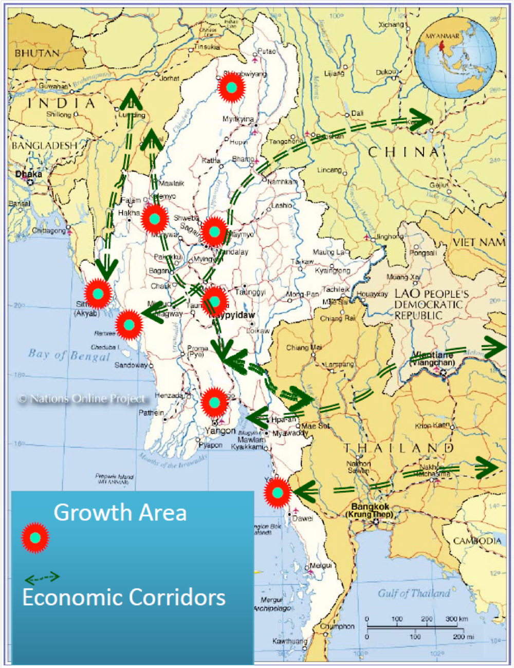
Growth Areas and Economic Corridor
Growth areas and economic corridor are attracting attention as the traction power to develop national economy, and Ministry of National Planning and Economic Development (MNPED) expresses intention to place special economic zones (SEZ)with focus on the growth areas. Ministry of Construction (MOC) has the idea of designating eight (candidate) growth areas as shown on the figure on the right hand side. Meanwhile, MNPED is pointing out only three cities -- Yangon, Mandalay, and Taunggyi (state capital of Shan State) -- with mentioning about the possibility of adding more. That means the actual designated areas are unfixed.
Dawei, Thilawa (Yangon), and Kyaukpyu -- the first, second and third coastal growth areas from south, in the figure on the right -- are the only SEZs so far to be designated based on the Myanmar Special Economic Zone Law legislated in January 2011. The three SEZs are expected to be the core areas to attract foreign investment hereafter.
No comments:
Post a Comment